Saturday, April 24, 2010
Night time in Wellington

East Cape Roadie: Day 3 and homeward bound


Raukokore Anglican Church with bay in background

Inside of the church 1

We carried along this coastal road passing many quiet, small and isolated beeches. Around 10/11 ish we reached the Pacific Coast Macadamia nut plantation located between Opotiki and Hicks Bay (http://www.macanuts.co.nz/index.cfm). We all had muffin containing Macadamias and I think feta? Can’t quite remember but they were yummy. I bought some honey roasted Macadamia nuts after trying Katrin's, with the aim to post some homeward. Unfortunately, I don’t think they even made it to the end of the trip, they were so yummy. Sorry guys!
A very short distance from the plantation was a small track into the forest to a waterfall. So, we decided to go for a little exploration. Sure enough, after around 10 minutes walking through the bush and over the small stream, we reach the water fall. Katrin and John decided to go for a little swim. Apparently the water was very cold and I was not tempted to join the two of them.


Fern (a plant photo just for Claire. I know how much you like New Zealand flora!)

Waterfall
We got back into the van and journeyed on. We stopped and took a late lunch just before the small town/village of Opotiki. Today was the hottest day we had all weekend. My very white skin was getting scared, so from now on I had it covered up. My opinion, it’s better to be covered and white than burned. We took off again and were soon heading south back down to Gisbourne.

Lunch near Opotiki : The kiwis! (Jan's photo)
 Lunch near Opotiki: The internationals! (Jan's photo)
We took one last stop to look at the Tauranga Bridge. This is a “historic” bridge built in 1920s to provide access to the farm land on the other side of the Waioeka gorge. Not long after this the farmers realised how unproductive this land was and abandoned the area. It is now part of the Waioeka Scenic Reserve. Although it sounds a bit boring, it was actually rather pretty. The bridge itself looked substantial but apparently a maximum of only 10 people could go on it. Bearing this in mind, I jumped along the bridge making it shake and wobble from side to side. There were only 5 of us on the bridge, so it was fine!! Honest!

Tauranga Bridge


View down river

Bridge again
 Not sure what we were looking at but I'm sure it was interesting. (Jan's photo)
So we were Gisbourne bound. Prior to our last stop Katrin and John had fallen asleep. John had been doing very well with the bingo and only needed 1 more item to win. So whilst they were sleeping, Jan, Debs and I took advantage of the lack of competition. It proved a profitable period as we all caught John up and I only needed 1 more item ... a logging truck!! These are usually common as the region has a large forest industry, however we neglected the fact that it was Sunday and there where no logging trucks in site!! But I was determined to win (I am a Callard after all!!). I had it all planned out, when I see a logging truck I will calmly point it out and quietly say bingo. However as the miles and time went pass, the hope of finding a truck grew less and less.
At around 5pm we started to head into Gisbourne. Then, in the corner of my eye I saw a large, red, shiny object. I turned, pointed and shouted in the loudest girly scream you can imagine “LOGGING TRUCK”. My plan of being cool failed and the fact I was in the front seat also nearly caused us to crash. But I won with only 10 minutes left of the trip.
We went back to the same campsite we stayed on the first night, put up our tents and ate fish and chips. Our last supper before returning back to wellington.

Chips! (Jan's photo)

It was going to be around an 8 hr drive back to wellington. John was staying behind to help Andy with his field work, so we said our goodbyes and started our trip home rather subdued. We had checked the forecast prior to setting off and knew we were heading towards bad weather. Along our way we stopped for our last lunchtime pie and also acquired a cheese cake from Yummy Mummy cheesecakes in Woodville. I gave it a try but cheesecake really isn’t something I liked. We continued south and then we saw it!! Dark clouds were growing ahead by the hills surrounding wellington. It was like looking at Mordor!! It got darker the closer we got, then came the rain and finally the strong westerly winds. And that was it, the end of our trip away.
Thursday, April 1, 2010
East Cape Roadie: Day 2


Blue water!!


 John enjoying a cider (Jan's Photo)
We continued north and drove through lots of little villages/ towns. It was a bit sad, as the scenery is absolutely amazing and as lucky tourist we can admire the rustic, rural setting, but the reality is a bit different. This is not the wealthiest region of New Zealand so many of the villages seemed like ghost towns. In some instance more house were boarded up than were being lived in.

I think Tokomaru Bay, town houses (Jan's Photo)
 Tokomaru Bay?, houses (Jan's photo)
We carried on driving, taking advantages of viewing points along the road taking pictures until we reached Hicks Bay, located the furthest north east of the Cape. There was supposed to be a camping ground nearby, but the books didn’t state where. We chose a road heading toward the beach and stumbled across a small village which was an old pā site, a Maori village, in Onepoto bay (the East Cape still has a very strong Māori heritage). We noticed a sign on a gate stating that there were camp sites and sleeping quarters which we could use. John, Katrin and myself went to investigate, however having seen a huge Rottweiler and an Alsatian, Katrin and I decided it would be best for John to go on his own. After a few minutes, it turned out that a Māori family rented out the ground and a dorm for travellers to use, and it was perfect!!
So, we spent the second night at Mel’s place. After we were settled in John, Debs and I went swimming in the bay and I have never been in such warm water. I could have stayed in there forever. We body surfed a couple of waves in the perfect blue water and then headed back to the house. Katrin, had also never been fishing before, so John and her went fishing. An hour or so later, whilst reading I could here an enormous screech, Katrin had caught her first fish. Sadly, it was too small to eat and it had also swallowed the hook. After an apparently gruesome struggle with the hook, John decided it was best to kill the fishy and send it back to a watery grave!
We spent the rest of the evening eating a veggie curry, drinking a few beers and enjoying the evening/night outside on the decking.

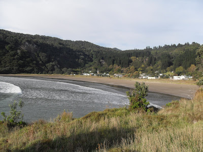
Onepoto bay
 Onepoto bay: the small flat peninsula is Mel's place
East Cape Roadie: Day 1
We drove north and after a few stops, to drop off a radiator and spade retreaval, we were soon on the open road. And what a lovely open road it was. Once past the hills trapping us in Wellington, the weather completely changed. It was much warmer and incredibly sunny. The scenery, as always, was beautiful. We stopped for lunch at Dannevirke, a town settled by the dutch, and ate the mandatory pie. Apparently there is an electronic public toilet that plays “why to birds suddenly appear …” on a continuous loop. For fear of getting the song stuck in my head I opted out of a toilet break.

View from a vantage point somewhere on the way (Jan's photo)

We drove northwards for a few more hours, until we reached Lake Tutira. The others have all been on field trips here, either demonstrating of being taught. Apparently, there had been a large landslide, which now separates Lake Tutira from Lake Waikpiro, blocking the water flow and hence building the lake. Or something like that. To be honest I was feeling a bit tired so wasn’t fully concentrating.


After a 20 min break we continued our journey. 8-9 hours later, we reached are fist stop for the night, Gisborne. This is located on the east coast and is a typical tourist surfer beach town. We stayed at a camp site and set up our tents. Katrin is Austrian and thereofre being from a landlocked country had never learned to surf, so John took her out for her first surf. Although she didn’t manage to stand, she did really enjoyed herself. The rest of us went to the shops and bought the food for the the trip.
Once Katrin and John had had enough of their surfing we ate tea, played a game of cards and promptly went to bed. We were going to set off reasonably early the next day to explore the East Cape.


